


 Home
Home
United States
 |
In many low-lying coastal cities around the world, people have pushed development right out to the water’s edge. On most days, such closeness to the water is a pleasure, even a luxury. But when hurricanes and tropical storms approach, it’s a different story. People can evacuate themselves, but they can’t take their homes, airports, or roadways with them. ....read more |
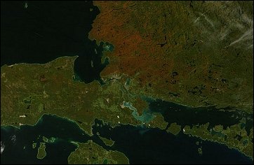 |
The calendar may have set September 23 as the first day of autumn in 2007,
but the forests that line the eastern shore of Lake Superior had
already started to mark the turning of the season. ....read more |
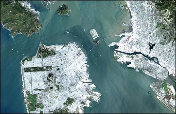 |
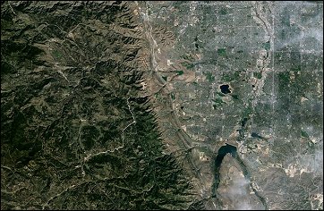
On a rare fog free day Landsat 7 flew over San Francisco (United States) and
produced this stunning true color image. You can easily see both man
made structures - the Golden Gate Bridge, the Bay Bridge, Alcatraz,
and Oakland International Airport ..... ....read more |
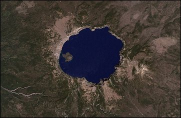 |
Crater Lake National Park is one of the oldest parks in the United States, created in 1902 by President Theodore Roosevelt. The first lodge in the park opened in 1915, and the Rim Drive around the lake gave the public easy access to the entire lake in 1918. Soundings of the lake show it is exceedingly deep, reaching as low as 1,943 feet (592 meters), making it the deepest lake in the United States..... ....read more |
 |
Delaware Water Gap National Recreation Area is a National Park on the border
of New Jersey and Pennsylvania (United States). The park runs
roughly 40 miles along the Delaware River and the Appalachian
Mountains, which are immediately adjacent to the river. ....read more |
 |
On May 18, 1980, the Mount St. Helens volcano erupted. A series of earthquakes preceded the eruption and triggered a collapse of the north side of the mountain into a massive landslide. This avalanche coincided with a huge explosion that destroyed more than 700 square kilometers of forest... ....read more |
 |
Augustine Volcano in the Gulf of Alaska (United States) erupted on December
12, 2005, sending a plume of ash and steam approximately 80 kilometers (50 miles) toward the
southeast. The Moderate Resolution Imaging Spectroradiometer (MODIS) flying onboard the Aqua
satellite captured this image the same day. In this image, ..... ....read more |
 |
Snow across the burnt-orange rock of the Colorado Plateau (United States)
makes the rugged topography of the Grand Canyon of the Colorado River leap out from the center of this image
captured by the Moderate Resolution Imaging Spectroradiometer (MODIS) sensor on NASA’s Aqua satellite on November 23, 2004.....
....read more |
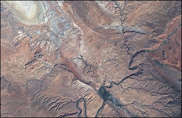 |
Arches National Park in Utah (United States) is home to some 2,000 arches and windows in rock, as well as rock spires and pinnacles. Originally established as a national monument in 1929 by President Herbert Hoover, Congress gave it national park status in 1971. The park covers about 119 square miles of arid land..... ....read more |
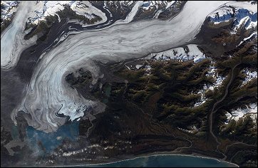 |
Bering Glacier currently terminates in Vitus Lake south of Alaska’s Wrangell-
St. Elias National Park, about 10 km from the Gulf of Alaska (United
States). Combined with the Bagley Icefield, where the snow that feeds the
glacier accumulates, the Bering is the largest glacier in North America..... ....read more |
 |
A powerful Alaskan storm swept over California (United States) during the final week of October, drenching the state with record rain and snow. The storm was the second large storm to move over California in as many
weeks, and it left the Sierra Nevada Mountains coated in snow..... ....read more |
 |
After carving its way through the Appalachian Mountains of New York and
Pennsylvania, the Susquehanna River passes by the towns of Havre de Grace (southwest bank) and Perryville (northeast
bank) and empties into the Chesapeake Bay in the very northeastern corner of Maryland (United States)..... ....read more |
 |
The Rio Grande River can be seen meandering through the area, forming the boundary between the sister cities of El Paso, Texas (United States), and Juárez, Chihuahua (Mexico). The setting sun has cast the east side of the Sierra Juárez and Franklin Mountains into shadow.
....read more |
 |
A late fall snowstorm frosted the hills of the Finger Lakes region of central New
York (United States) in early December. Shapes of the snow-covered hills are accented by the low Sun angles, and contrast with the darker, finger-shaped lakes filling the region’s valleys. ....read more |
 |
The Golden Gate National Recreation Area stretches from Tomales Bay north of Point Reyes all the way south to San Mateo County (California, United States). With 30,512 hectares (75,398 acres) of park land, it is one of the largest city parks in the world. Established as a National Park in 1972,..... ....read more |
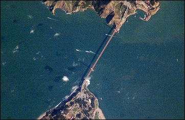 |
The Golden Gate of San Francisco Bay (United States) is one of the most
recognizable straits in the world due to the Golden Gate Bridge that spans it. This high-resolution astronaut photograph is a nearly cloud-free view of the northern part of the San Francisco metropolitan area. Immediately south of the bridge is the Presidio of San Francisco..... ....read more |
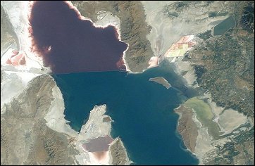 |
Great Salt Lake serves as a striking visual marker for astronauts orbiting over
North America. A sharp line across its center is caused by the restriction in water flow from the railroad causeway. The eye-catching colors of the lake stem from the fact that Great Salt Lake is hypersaline, typically 3-5 times saltier than the ocean, ..... ....read more |
 |
On the high peaks of Hawaii’s (United States) Mauna Loa (south) and Mauna
Kea (north) a cap of brilliant white snow covered the summits on January
14, 2005, when this image was captured by the Moderate Resolution
Imaging Spectroradiometer (MODIS) on NASA’s Aqua satellite. ....read more |
 |
This astronaut photograph depicts the San Jacinto River portion of the Houston Ship Channel, one of the United States’ busiest sea ports. The channel is a conduit between the continental interior and the Gulf of Mexico for
both petrochemical products and Midwestern grain. ....read more |
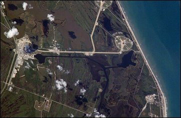 |
International Space Station Astronaut Leroy Chiao, like the rest of NASA, tracks key milestones for the Space Shuttle Return-to-Flight operations. A lucky overpass of the Space Station over Florida (United States) on April 6, 2005, allowed Leroy and his crew mate Salizhan Sharipov a unique view of the rollout of the Space Shuttle Discovery. ....read more |
 |
In southern West Virginia (United States), the New River carves a rugged, steep-sided gorge through a plateau of ancient sandstone and shale. From its headwaters high in the mountains of North Carolina, the New flows northward hundreds of miles through Virginia and into West Virginia. ....read more |
 |
Skiers, hikers, and tourists prize Colorado’s (United States) Rocky Mountains for what they offer today: steep ski slopes, challenging climbs, and spectacular views. Geologists and paleontologists prize the region for the information it offers about the past. ....read more |
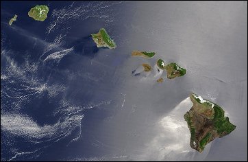 |
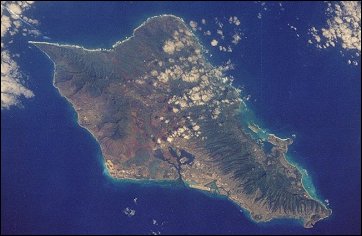
A silver swath of sunglint surrounds half of the Hawaiian islands (United
States) in this true-color Terra MODIS image acquired on May 27, 2003. Sunglint reveals turbulence in the surface
waters of the Pacific Ocean. If the surface of the water was as smooth as a perfect mirror,.... ....read more |
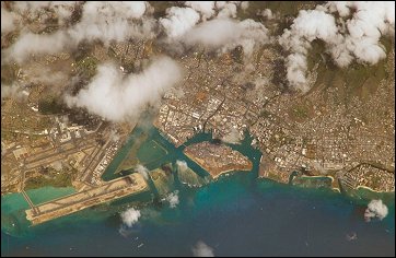 |
When you fly right over the top of the islands you can look down and see the
city of Honolulu near Pearl Harbor (United States). If the weather is good and the air is clear (and it almost always is in Hawaii) you can see objects as small as maybe a quarter of a mile in size with your bare eyes. ....read more |
 |
Oahu, Pearl Harbor, Honolulu, Diamond Head, the sheer Pali cliffs, and the famous winter surf on the north shore of the island all were easily visible to the fourth crew aboard the Challenger. Oahu is the third island from the north end of the Hawaiian chain and is representative of that part of Hawaii where... ....read more |
 |
In the western United States, water is the most critical natural resource. In
addition to drinking supplies, water sustains agriculture, provides hydroelectric power, and nourishes ecosystems. The
artificial Lake Powell and Lake Mead reservoirs on the Colorado River are the most important water caches in the
West.... ....read more |
 |
The Mississippi River drains the heart of the North American continent, carrying vast quantities of sediment and depositing it along the shore of Louisiana (United States) and into the Gulf of Mexico. The sediment is composed of topsoil, sand, dead and decaying plants, and .... ....read more |
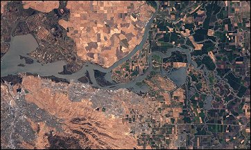 |
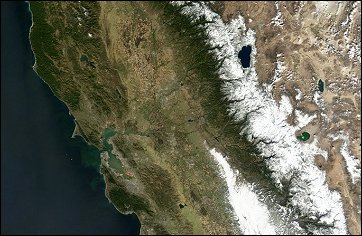
Between the two of them, the Sacramento and the San Joaquin Rivers drain
most of the state of California, collecting and concentrating rainfall and snowmelt form the Sierra Nevada and funneling it toward San Francisco Bay. On the western side of the great Central Valley in northern California,.... ....read more |
 |
Situated between the South Carolina piedmont and the Atlantic Ocean, the Savannah River Site is an important part of the U.S. Department of Energy’s nuclear program. Construction of the site - originally called the Savannah River Plant - began in 1951 for the purpose of generating radioactive materials..... ....read more |
 |
Tucson, Arizona (United States) lies between the forested Catalina Mountains and the Tucson Mountains (dark reddish brown at the left image margin).The typical western North American cityscape is a pattern of regular north-south aligned rectangles outlined by major streets set one mile apart. ....read more |
 |
Mined for gold, silver, and copper, the region of Butte, Montana, USA, had
already earned the nickname of “The Richest Hill on Earth” by the end of the 19th century. Demand for electricity increased demand for copper so much that by World War I, the city of Butte was a boomtown...... ....read more |