


 Home
Home
NASA WorldWind Support
![]() PhotoGlobe now supports NASA WorldWind 1.3.2 or later. This gives you the opportunity to jump from the satellite image to the respective ground photo.
PhotoGlobe now supports NASA WorldWind 1.3.2 or later. This gives you the opportunity to jump from the satellite image to the respective ground photo.
What is NASA WorldWind?
NASA WorldWind is a phantastic piece of software which lets you look at the earth from a satellite's perspective. You can zoom into any area of the world down to a level where you can see (at least in theory) individual cars. However, the currently available LandSAT images are of lower resolution offering a scale which is equivalent to a 1:100000 scale of a conventional map.Where can I get WorldWind?
You can download NASA WorldWind directly from the NASA site at worldwind.arc.nasa.govHow does PhotoGlobe support WorldWind?
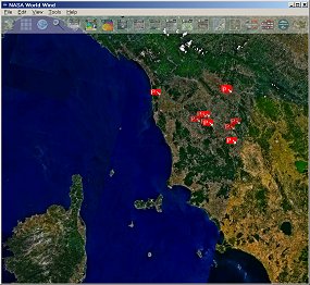 PhotoGlobe provides an installable plugin, which indicates the photo positions offered at the PhotoGlobe Web site by flags displayed on the WorldWind surface (for example, at the right you see the positions of a few photos of Tuscany/Italy indicated by the little red spots on the satellite image).
Of course, you can selectively turn on and off photo points of individual countries and regions by using the built-in layer manager. If you move the mouse over the photo points, WorldWind displays the caption of the photo. Clicking a photo point will bring up a browser window connecting you directly to the photo corresponding to the photo point.
Installation of the PhotoGlobe WorldWind-plugin
The installation of the plugin is straightforward and quite simple:- Required minimum WorldWind release: 1.4 (if you have installed an older version, you should update to the latest release; all the releases before 1.3.2 are too buggy)
- Download the installation file from here: PhotoGlobe_WW_20090324.zip [approx. 112 kB]
- Unpack the ZIP archive (it contains the installation executable photoglobe.exe)
- Close NASA WorldWind if it is running
- Run the installation file photoglobe.exe. Hint: please use the default directory suggested by the installer program, otherwise WorldWind can't find the photo positions.
- Start NASA WorldWind again - that's it! Now you see little red flags indicating the photo positions. In order to (de)select groups of photos simple use the layer manager of WorldWind.