
|
Photos - Swiss Alps (Switzerland) |
|
The Alps arose as a result of the pressure exerted on sediments of the Tethys Ocean basin as it was pushed against the stable Eurasian landmass by the northward-moving African landmass. Crystalline rocks, which are exposed in the higher central regions, are the rocks forming Mont Blanc, the Matterhorn, and high peaks in the Pennine Alps and Hohe Tauern. The landscape seen today is mostly formed by glaciation during the past two million years.
The western Alps which belong to France, Switzerland and Italy are higher than the eastern part, with Mount Blanc being the highest mountain in Western Europe. Its 4,807 m high peak lies in the ridgeline of the Pennine Alps and the peak defines the border between France and Italy. The Swiss Alps in particular are regarded as climber's paradise, offering such well-known peaks as the Matterhorn, or the Eiger with its North Face towering over 1800 m above the valley. If you are planning to visit the Swiss Alps you may be interested in having a quick look at several photos of this area. Click on the links below to view the pictures. We have taken any attempt to provide exact (GPS-based) coordinates of the positions where the photos have been taken. |
|
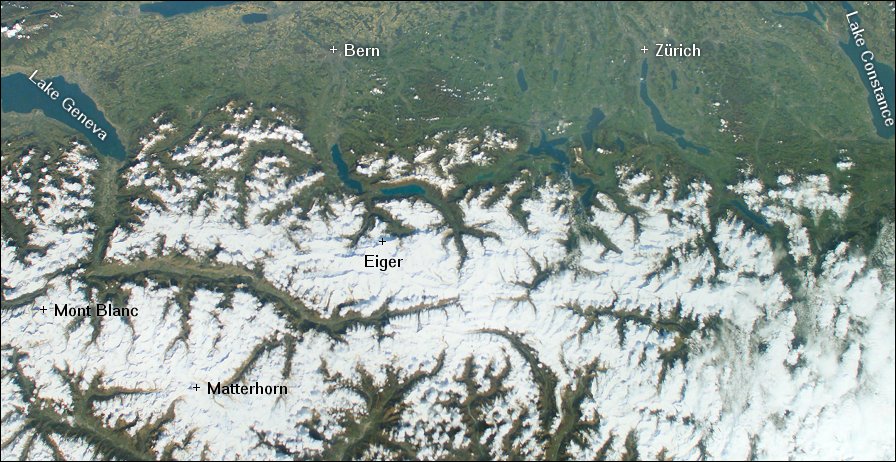 Here you see the Swiss Alps from space. Image courtesy of Earth Sciences and Image Analysis Laboratory, NASA Johnson Space Center. |
|
|
Matterhorn - Matterhorn North Face - Zmutt Valley - Clouds hide the summit of Matterhorn - Monte Rosa and Lyskamm - Rimpfischhorn - Kleinmatterhorn - Monte Rosa - Blümlisalp - Wild Glaciers - Glacier Tongues - Moraine walk - Großer Mythen - Rigi - Lake Lucerne - Salbitschijen - Vadret da Tschierva - Biancograt (Bianco ridge) - Piz Roseg - Sunrise in the Bernina - Piz Roseg - West Face - Piz Glüschaint - Taking a nap - Sunrise at Salbit - Salbitschijen - Salbitschijen - South Ridge - Lake Lucerne and Pilatus seen from Hoch-Ybrig - Hoch-Ybrig - Sihlsee - View from Roggenstock - Großer Mythen and Kleiner Mythen - Klewenalp - View to Klewenalp - On the way to Hinterjochli - Klewenalp and Lake Lucerne - Clariden from Hinterjochli - Brunnistock - View from Hinterjochli to the south-east. - Brunnigstock and Wissigstock - View of Brisen - Brunnigstock and Wissigstock - Lake Lucerne - Ridge to Brisen - Descent to Gitschenen - Thuner See and Berner Oberland - Eiger - North Face - Mönch North-East Face - Wetterhorn - Grindelwald Train Station - Track from Jungfraujoch to Mönchsjoch - Jungfrau - Mönch - Mönchsjoch - Ascent to Mönch - Jungfraufirn - Aletschgletscher
|
|