
|
Photos - Tenerife (Spain) |
|
Tenerife is the largest island of the seven Canary Islands (belonging to Spain). The Canary Islands are also known as the "Islands of Eternal Spring". In fact, temperatures change little over the year due to the thermostatic effect of the Atlantic. However, there's much difference in the overall climate between the dry and barren eastern islands (Lanzarote and Fuerteventura) and the wet and fertile western ones (La Palma and El Hierro). Tenerife, Gran Canaria and La Gomera come in between. Tenerife is - as the entire archipelago - of volcanic origin and accomodates Spains highest mountain, the 3718 m high El Teide. Due to the northeasterly Passat winds the northern part of Tenerife is much wetter than the barren south. So it's your choice: if you want to get sunburned in the shortest possible time, stay in the south; if you like culture and easy living, stay in the north... If you are planning to visit Tenerife you may be interested in having a quick look at several photos of Tenerife. Click on the links below at the right to view the pictures. We have taken any attempt to provide exact (GPS-based) coordinates of the positions where the photos have been taken. |
|
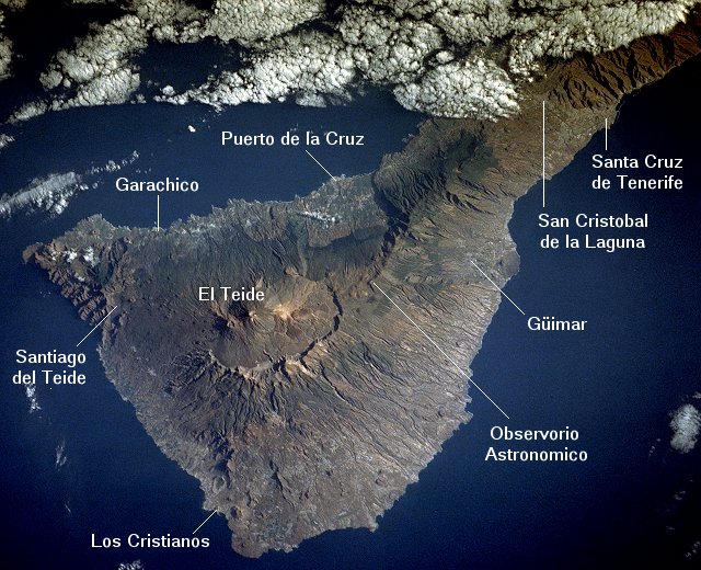 Here you see part of Tenerife from space. Image courtesy of Earth Sciences and Image Analysis Laboratory, NASA Johnson Space Center. |
Area between San Cristobal and Aeropuerte del Norte Valley of San Cristobal with El Teide in the Background Las Mercedes View from Pico del Inglés Anaga Ridge Playa de Las Teresitas View from Mirador de San Pedro El Teide Observatorio Astronomico Arenas Blancas Los Roques Cañada de Pedro Méndez seen from Los Roques Los Roques and El Teide Pond in the Botanic Garden Red Blossom El Guincho with Garachico in the Background Market Place of Garachico Garachico Santiago del Teide Ravine of Masca Cones of Clinker Puerto de la Cruz and its Surroundings Main Church of Puerto de la Cruz |