 |
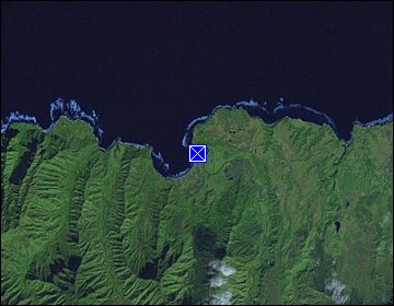
Hawaii/Kauai: Hanalei Pier |
Album Overview
Photo Index
  |
|
More photos in the vicinity: Hanalei Bay Hanalei Beach Hanalei Beach |
Originally built in 1912, the Hanalei Pier was used to transport rice out of the valley. The port was eventually closed to commercial use, but is still popular today with fisherman and boaters. |
|
|
Date: Dec 09, 2006 Longitude: -159° 29.83' Latitude: 22° 12.76'  
Show Photo Position in Google Maps |
||
   Map references: left: courtesy CIA, middle: courtesy US LoC Map Collection, right: courtesy NASA. This page has been updated on: 2011-Jul-28 |
||