
|
From Marrakech into the Desert - Morocco |
|
Morocco is a country in the northwest of Africa with a population of 34 million, comparable in size to Iraq or California. The Atlas Mountain Range, running from the north east to the south west, forms the backbone of the country. The region south east of the Atlas Mountains belongs to the Sahara Desert. We set out from Marrakech driving through the Atlas mountains into the desert. Near the Algerian border we started our 5-day hiking tour through the desert where most of the photos originate from.
If you are planning to visit the south east of Morocco you may be interested in having a quick look at these photos. Click on the links below to view the pictures. We have taken any attempt to provide exact (GPS-based) coordinates of the positions where the photos have been taken. |
|
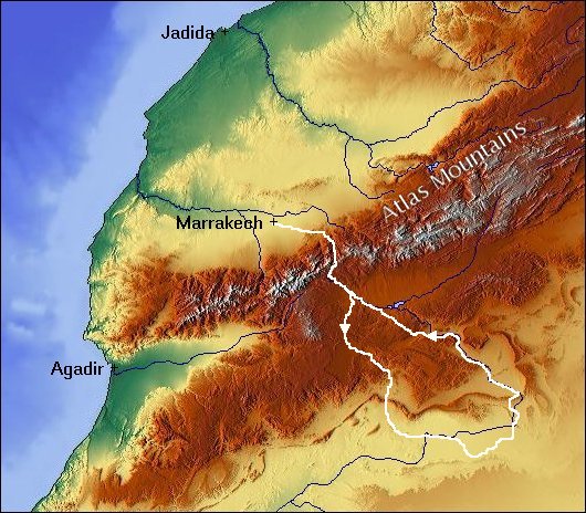 Here you see a relief map of central Morocco and Western Algeria. Image courtesy of Maps for Free. |
Rahba Kedima in Marrakech Carpet Trader in Marrakech Spice Trader in Marrakech The Tower of a Mosque seen from a Roof Terrace Badii Palace in Marrakech The Road from Marrakech to the Atlas Mountains High Atlas south of Tizi-n-Tichka In the Atlas Mountains Village in the Atlas Mountains Tazenakht Tazenakht Erg el M'hazil At the Border to Algeria Sand Dune Jbel Bani Border between Morocco and Algeria Dromedary Dry River Bed Sand Dunes Camp in the Desert Dromedaries in the Desert Tamarisks in an Oasis Dunes in the Evening Sun Sand Dunes in the Morning Sun Huge Sand Dune Huge Sand Dune Tomb of Sidi Naji Camp in the Desert Oasis near Mhamid |